

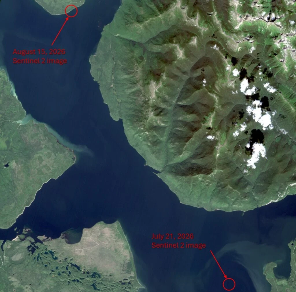
The Canadian utility BC Hydro has successfully relocated a massive, wandering landmass within the Williston Reservoir, resolving a geographical mystery that had captured the attention of national media and the international "GeoGuessr" community. The island, which spans approximately the size of two professional football fields and features a surprisingly mature ecosystem of vegetation, was rediscovered in a remote section of the reservoir after seemingly vanishing from its initial sighting location. While the event has sparked significant public curiosity, it has also prompted a serious technical assessment by hydroelectric engineers regarding the potential risks such nomadic masses pose to critical energy infrastructure.
The saga began in late July 2026 and culminated on Monday, August 31, when satellite imagery confirmed the island’s new position in the Ospika Arm of the reservoir. This location is roughly 30 kilometers northwest of where the island was first reported by recreational boaters near Finlay Bay. The discovery of a mobile, vegetated island in a man-made reservoir is a rare phenomenon, raising questions about the geological stability of shorelines and the impact of fluctuating water levels on hydroelectric operations.
A Chronology of the Wandering Island
The timeline of the island’s discovery and subsequent "disappearance" highlights the challenges of monitoring a reservoir as vast as Williston, which serves as the largest body of fresh water in British Columbia.
On July 21, 2026, local boaters operating west of Finlay Bay reported a significant landmass that did not appear on any known navigational charts or previous satellite maps. This location is situated approximately 100 kilometers from the W.A.C. Bennett Dam. On August 13, BC Hydro was officially notified of the sighting. Initial skepticism from utility officials was quickly replaced by intrigue when satellite passes confirmed the presence of a heavily vegetated mass that appeared to have materialized out of nowhere.
However, shortly after this confirmation, the island disappeared from view. Subsequent satellite passes of the Finlay Bay area showed only open water, leading to speculation that the island had either broken apart or submerged. The mystery was solved on August 31, when a review of imagery dated approximately two weeks prior revealed the island had drifted significantly. It had come to rest against a shoreline in the Ospika Arm, approximately 280 kilometers north of Prince George, B.C.
Bob Gammer, a spokesperson for BC Hydro, confirmed that the island appears to remain entirely intact despite its 30-kilometer journey. The utility noted that while the island was "lost" to satellite tracking for a brief window, it had likely been moving steadily under the influence of prevailing winds rather than reservoir currents.

Physical Characteristics and Biological Composition
One of the most striking aspects of the Williston Reservoir island is its advanced state of ecological development. Unlike simple debris jams or log rafts frequently found in hydroelectric reservoirs, this landmass features "mature-looking vegetation." Observers from small aircraft and nearby boats have reported seeing shrubs and small trees, suggesting that the island has been in a state of formation for several years, if not decades, before it became buoyant.
The island’s size—roughly two football fields—makes it a significant physical entity. Its stability suggests a deeply interconnected root system and a thick substrate of organic matter. Geologists and environmental scientists note that such islands, often referred to as "tussocks" or "floating mats," are typically composed of peat, decomposing wood, and sediment. These materials become buoyant when gases—such as methane or carbon dioxide produced by decomposition—become trapped within the organic matrix, eventually lifting the entire section of the shoreline or bay floor to the surface.
The W.A.C. Bennett Dam and Operational Safety
The primary concern for BC Hydro throughout this event has been the safety of the W.A.C. Bennett Dam and the associated Gordon M. Shrum Generating Station. Located on the Peace River, the W.A.C. Bennett Dam is a cornerstone of the Western Canadian power grid.
The dam is a massive earth-fill structure, and its generating station has a nameplate capacity that allows it to produce more than 13,000 gigawatt-hours (GWh) annually. This output is sufficient to meet more than one-third of the total electricity demand for the entire province of British Columbia. Given the scale of this infrastructure, any large floating object represents a potential "operational impact" if it were to migrate toward the dam’s intake towers or spillway gates.
Floating islands can cause catastrophic damage if they are drawn into hydroelectric intakes, potentially clogging trash racks or damaging turbine components. Fortunately, the island’s current position in the Ospika Arm is further away from the dam than its initial sighting point. BC Hydro officials have stated that, based on current wind patterns and the island’s distance from the Peace Canyon, there is no immediate threat to power generation or structural integrity.
Environmental Drivers: The Role of Water Levels and Weather
The emergence of the island in the summer of 2026 is not viewed as a random occurrence by BC Hydro engineers. Instead, it is likely the result of specific hydrological conditions. During June and July 2026, BC Hydro was forced to open the spillways at the W.A.C. Bennett Dam to manage an influx of water. This surge was caused by a combination of an unusually high winter snowpack and heavy, saturating summer rainfall across the Peace River watershed.
"Higher reservoir levels can lift material that may have been lodged along the shoreline or in a sheltered bay, allowing it to float free," Gammer explained.

In the case of the Williston Reservoir, the high water levels likely provided the necessary buoyancy to "pop" the island off the floor of a shallow bay. Once detached from the bottom, the island became a sail. Because much of the landmass sits above the waterline and is covered in foliage, it is highly susceptible to wind-driven migration. In large reservoirs like Williston, wind can exert more force on a floating mat than the relatively slow-moving internal currents, explaining why the island moved 30 kilometers in such a short timeframe.
Technical Analysis of Floating Island Formation
The formation of such a large floating landmass is a complex process that involves several stages of maturation. While BC Hydro’s official stance is that the origin is currently unknown, the leading theory involves the accumulation of woody debris.
Historically, when reservoirs are filled, large amounts of timber and organic material are submerged. In some areas, this material forms a dense floor. Over decades, as this wood decomposes, it creates a nutrient-rich peat-like soil. Seeds from the surrounding forest are deposited by wind or birds, allowing vegetation to take root. As the plants grow, their roots lace the debris together, creating a singular, reinforced mass.
When water levels reach a critical threshold, the upward buoyant force exceeds the suction or weight holding the mass to the reservoir bed. The result is a "floating island." These phenomena have been documented in other parts of the world, such as Lake Chippewa in Wisconsin, where residents must occasionally use motorboats to push a giant floating island away from a bridge. However, in the deep and rugged terrain of northern British Columbia, such occurrences are significantly rarer and more difficult to manage.
Public Safety and Navigational Hazards
While the island has become a local curiosity, BC Hydro has issued a stern advisory to the public regarding interaction with the landmass. Although the utility has stated that it is safe for the public to observe the island from a distance via boat or drone, "climbing aboard the landmass is not advisable."
The stability of a floating island is deceptive. Unlike a permanent landmass, these mats can be thin in sections, and the weight of a human could cause a breakthrough into the cold, deep waters of the reservoir. Furthermore, because the island is not anchored, it can shift suddenly with the wind, potentially trapping small watercraft between the island and the reservoir’s rocky shoreline.
From a navigational standpoint, the island remains a hazard. For boaters accustomed to the familiar geography of the Ospika Arm, the sudden appearance of a two-acre landmass in what was previously open water could lead to collisions, particularly during night-time navigation or periods of low visibility.

Monitoring and Future Outlook
BC Hydro has committed to ongoing monitoring of the island’s movements. Using a combination of satellite imagery and occasional aerial reconnaissance, the utility will track whether the island continues to move northwest or if it eventually breaks apart.
"The island appears to be intact from when it was first spotted," Gammer noted, though he cautioned that there is no guarantee it will remain so. The structural integrity of such islands is often tested when they collide with shorelines or are subjected to heavy wave action during storms. If the island were to break into smaller fragments, it would pose a different set of challenges, as multiple smaller debris fields are harder to track than a single large mass.
As a general protocol, BC Hydro and other hydroelectric utilities across Canada rely on "citizen science" and reports from the public to manage the vast reaches of their waterways. The utility has encouraged anyone who spots significant changes in reservoir geography or new floating hazards to contact them immediately.
The "mystery island" of Williston Reservoir serves as a reminder of the dynamic nature of man-made environments. Even decades after the completion of a major project like the W.A.C. Bennett Dam, the landscape continues to evolve in response to the climate, the seasons, and the immense power of the water itself. For now, the island remains a silent, drifting resident of the Ospika Arm, a testament to the unpredictable intersection of engineering and ecology.
