

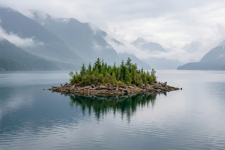
Utility officials and residents in northern British Columbia are grappling with a geological and navigational enigma following the appearance—and subsequent disappearance—of a massive, vegetated landmass in the Williston Reservoir. The floating island, estimated to be approximately 70 meters wide and 140 meters long, or roughly the equivalent of two standard football fields, was recently documented drifting through the seventh-largest man-made lake in the world. While such phenomena are not unheard of in large-scale hydroelectric reservoirs, the sheer scale of the forested mass and its current unknown location have prompted a closer look at the environmental and operational dynamics of the region’s power infrastructure.
The incident first gained public attention when Rocky Avery, a resident of northern British Columbia, shared photographic and video evidence provided by a friend who had encountered the island while navigating the reservoir. Avery’s decision to go public was motivated by safety concerns, particularly with a local fishing derby scheduled on the lake. The presence of a wandering, forested landmass poses a significant hazard to small watercraft and, more critically, to the massive hydroelectric infrastructure that regulates the Peace River.
Geographic and Engineering Context of the Williston Reservoir
The Williston Reservoir is a cornerstone of Western Canada’s energy grid. Formed in the late 1960s by the construction of the W.A.C. Bennett Dam, the reservoir covers an area of approximately 1,761 square kilometers (680 square miles). It is the largest body of fresh water in British Columbia and serves as the primary storage basin for the Gordon M. Shrum Generating Station.
The W.A.C. Bennett Dam is an engineering marvel of the 20th century. Standing 183 meters high and stretching 2 kilometers across the Peace River valley, the earth-fill dam impounds a staggering 74 cubic kilometers of water. The Gordon M. Shrum Generating Station, located deep within the bedrock adjacent to the dam, houses ten massive turbines with a total capacity of over 2,700 megawatts. This facility alone generates more than 13,000 gigawatt-hours of electricity annually, accounting for nearly 25% to 33% of the total power demand for the province of British Columbia.
Given the scale of these operations, any foreign object of significant mass—let alone a two-acre island with mature trees—is viewed with extreme caution by BC Hydro, the provincial crown corporation responsible for the site.
Chronology of the Floating Landmass
The timeline of the island’s discovery and its subsequent "vanishing" aligns with a period of unusual hydrological activity in the Peace River region.
- June and July 2024: Following a winter of significant snowpack accumulation and a summer characterized by saturating rainfall, BC Hydro initiated the opening of the W.A.C. Bennett Dam spillways. This was the first time in several years that such a volume of water had been released to manage reservoir levels, which reached a 14-year high.
- Early August 2024: As the water levels peaked, the floating island was first spotted. Observations indicated that the mass was not merely a collection of driftwood but a cohesive unit of earth, peat, and mature vegetation.
- Mid-August 2024: Following Rocky Avery’s reports, BC Hydro officials initially expressed skepticism. However, after reviewing high-resolution satellite imagery, the utility confirmed the island’s existence. The satellite data allowed technicians to measure the mass at 70 by 140 meters.
- August 3 to Present: Since the last confirmed satellite sighting on August 3, the island has disappeared from view. Despite ongoing monitoring of satellite feeds and local reports, the landmass has not been re-acquired by visual or digital sensors.
The Science Behind Floating Islands
The formation of floating islands, technically known as "tussocks" or "floating peat mats," is a documented but infrequent occurrence in large reservoirs. The process is typically driven by a combination of hydrostatic pressure and biological decomposition.
When a reservoir is created, vast areas of forest floor and peatland are submerged. Over decades, anaerobic decomposition of organic matter beneath the sediment can produce gases, primarily methane and carbon dioxide. These gases become trapped within the root mats and peat layers. When water levels rise significantly—as they did this summer in the Williston Reservoir—the increased buoyancy and upward hydrostatic pressure can cause sections of the shoreline or submerged peat beds to detach from the underlying substrate.
Once detached, these "islands" can remain buoyant for extended periods, held together by the intertwined root systems of the trees and shrubs growing upon them. The fact that the Williston island featured mature flora suggests that it was a section of the original shoreline or a long-submerged "shelf" that finally gained enough buoyancy to break free.
Operational Risks and Infrastructure Safety
BC Hydro’s primary concern regarding the wandering island is the potential for "infrastructure interference." While the Williston Reservoir is vast, the movement of such a large mass is dictated by wind patterns and surface currents. If the island were to drift toward the W.A.C. Bennett Dam or the Peace Canyon Dam further downstream, the consequences could be severe.

The intake structures for the Gordon M. Shrum Generating Station are protected by trash racks designed to filter out debris, but they are not built to withstand the impact or the clogging potential of a 140-meter-long forested landmass. Furthermore, if the island were to break apart near the spillways, it could obstruct the gates, complicating the utility’s ability to manage water levels during future flood events.
A spokesperson for BC Hydro noted that the utility is "monitoring the situation closely," though they acknowledged the difficulty of patrolling a reservoir of that size. The reservoir’s shoreline exceeds 1,700 kilometers, much of it in remote, inaccessible wilderness.
Comparative Global Incidents
The phenomenon of floating islands is a global challenge for hydroelectric and water management authorities.
- Lake Chippewa, Wisconsin: This man-made flowage is famous for its "moving islands." Local boat owners frequently have to use their vessels to push floating peat mats away from bridges and marinas. In some instances, dozens of boats have worked in tandem to relocate islands the size of city blocks.
- Lake Victoria, Uganda: In 2020, a massive floating island of water hyacinth and papyrus drifted into the intake of the Nalubaale Power Station in Jinja, causing a nationwide blackout. It took engineering teams several days to clear the debris and restore power.
- Lake Kariba, Zimbabwe/Zambia: One of the world’s largest man-made lakes frequently sees "islands" of Kariba weed (Salvinia molesta) that can become thick enough to support the weight of animals, creating navigational hazards for local fisheries.
The Williston Reservoir incident is unique due to the sub-arctic environment and the maturity of the trees involved, which increases the mass and potential kinetic energy of the island should it strike a structure.
Analysis of Current Status and Potential Outcomes
The current "missing" status of the island suggests several possibilities. First, it may have drifted into one of the many deep inlets or "reaches" of the reservoir, such as the Finlay or Parsnip reaches, where it could be obscured by the shadows of the surrounding mountains or hidden under the canopy of the shoreline forest. Second, the island may have lost buoyancy and partially submerged or broken into smaller, less recognizable fragments of debris.
From a management perspective, the best-case scenario for BC Hydro is that the island has "grounded" itself on a shallow bank far from the dam. Over time, as water levels recede, the mass could re-attach to the shoreline or stabilize in a remote area.
However, if the island remains intact and adrift, it remains a "ghost ship" of vegetation. BC Hydro continues to rely on satellite monitoring, but the vastness of northern British Columbia and the frequency of cloud cover in the region make consistent tracking difficult.
Conclusion and Future Outlook
The mystery of the floating island in Williston Lake serves as a reminder of the dynamic and often unpredictable nature of large-scale human interventions in the environment. Even decades after a dam’s construction, the land remains in a state of flux, responding to the pressures of fluctuating water levels and climate-driven weather patterns.
As of late August, utility officials remain on high alert. While the immediate threat to the power grid is considered low, the "re-vanishing" of the island has added a layer of mystery to the routine operations of the W.A.C. Bennett Dam. For the residents of the Peace River region, the floating forest is a testament to the power of the reservoir—a man-made sea that is still capable of producing surprises.
BC Hydro has indicated that it will continue to update the public should the island re-emerge on satellite surveillance. Until then, the two-acre forest remains somewhere in the 74 cubic kilometers of the Williston Reservoir, a wandering piece of the British Columbia wilderness.
