
A record-breaking heat wave is currently scorching the state of California, delivering a premature end to the winter season and placing significant strain on the state’s most vital natural reservoir: the Sierra Nevada snowpack. As temperatures shatter historical benchmarks for the month of March, water managers and climatologists are sounding the alarm over a rapid snowmelt that is altering the state’s hydrological calendar. While California’s man-made reservoirs currently remain at or above historic averages due to early winter storms, the "frozen reservoir" in the mountains is disappearing at an alarming rate, potentially leaving the state vulnerable during the high-demand summer and autumn months.
The Sierra Nevada snowpack is an essential component of California’s complex water infrastructure, traditionally providing approximately one-third of the state’s total water supply. Under normal conditions, this snow acts as a slow-release mechanism, melting gradually throughout the spring and summer to replenish lower-elevation reservoirs precisely when agricultural, urban, and ecological demands are at their peak. However, the current heat wave has shifted this timeline, triggering a swift runoff that is filling rivers and streams months ahead of schedule.
The State of the Snowpack: A Rapid Decline
According to data from the California Department of Water Resources (DWR), the statewide snowpack has plummeted to just 38% of its historical average for mid-March. This decline follows a volatile winter season that saw a promising accumulation of snow in February, only to be undermined by a series of warm, wet storms and the current extreme heat. State climatologist Michael Anderson noted that the current conditions are rapidly approaching the five worst snowpack years on record for the April 1st benchmark—the date traditionally used to measure the peak of the state’s water reserves.
Observations from the field indicate that the snow is currently disappearing at a rate of roughly 1% per day. This accelerated melt is a stark departure from the near-average conditions recorded just one year ago. The phenomenon is not merely a localized event; it is part of a broader trend driven by climate change, which is causing California’s runoff to occur earlier in the year. This shift leaves less water available during the hotter months for critical needs, including domestic consumption, irrigation for the Central Valley’s multi-billion-dollar agricultural industry, fish migration, hydropower generation, and forest health.
Chronology of the 2024-2026 Hydrological Cycle
The current crisis is the result of a specific sequence of meteorological events that began in late 2025 and escalated through early 2026.
- Late 2025 – Early 2026: Initial winter storms brought significant precipitation to the Sierra Nevada. These early-season "atmospheric rivers" were cold enough to build a substantial snowpack, while also soaking the soil beneath the snow. This saturated soil was initially viewed as a positive factor, as it meant that future melt would flow directly into streams rather than being absorbed by parched earth.
- February 2026: A series of heavy snowstorms bolstered the snowpack, leading to optimism among water managers that the state would see a "near-normal" water year.
- Early March 2026: A shift in atmospheric pressure brought an unprecedented heat wave to the West Coast. Temperatures in the Central Valley and the Sierra foothills reached record highs, some exceeding previous March records by double digits.
- Mid-March 2026: The heat wave persisted, leading to the current state of "rapid melt." High-elevation sensors began recording significant losses in Snow Water Equivalent (SWE), and river gauges showed a corresponding spike in flow volumes.
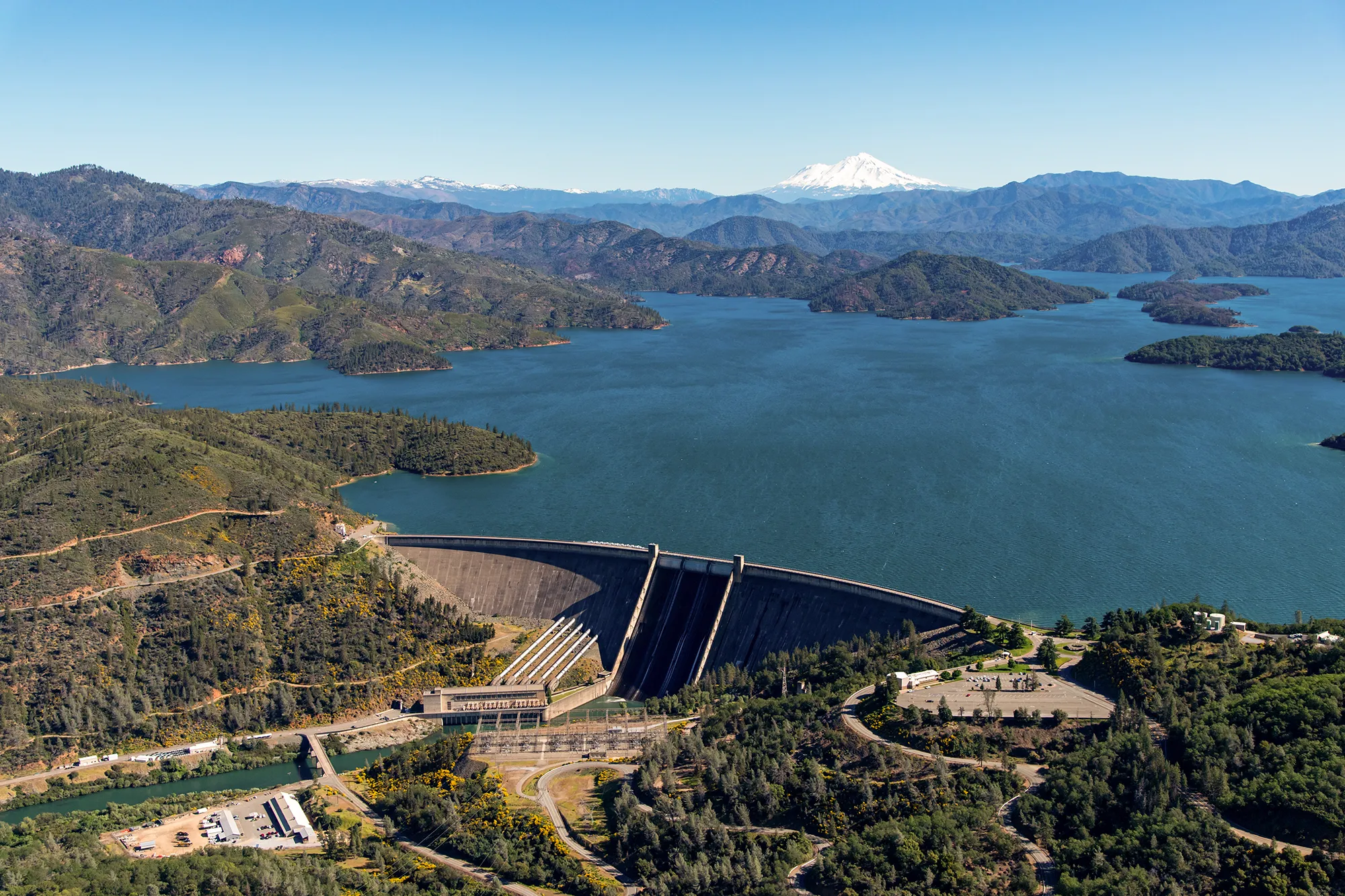
The Reservoir Management Dilemma: Flood Control vs. Storage
The early arrival of snowmelt has placed reservoir operators in a difficult position. Most of California’s major dams serve two primary, and often conflicting, purposes: flood control and water storage. During the winter months, federal regulations typically require reservoirs to maintain a "flood pool"—a specific amount of empty space intended to catch sudden surges from winter storms to prevent downstream flooding.
At New Bullards Bar, a massive reservoir in the Sierra Foothills fed by the North Yuba River, the conflict is currently on full display. Willie Whittlesey, General Manager of the Yuba Water Agency, reported that the reservoir is seeing snowmelt conditions in mid-March that are typically reserved for mid-May. While the reservoir is nearly full—at 114% of its average for this date—federal rules mandate that a certain amount of space remain empty until June.
"It’s pretty obvious that this is the runoff—this is the snowmelt—and it’s just happening about two months early," Whittlesey said. Without special permission to deviate from decades-old rulebooks, agencies like Yuba Water are forced to release water now to maintain flood safety margins, even if that water will be desperately needed later in the year.
This challenge is echoed across the state. The Central Valley Project (CVP), the federal system that moves water from Northern California to the Bay Area and the Central Valley, is also grappling with the loss of its mountain storage. Levi Johnson, operations manager for the CVP, emphasized that while reservoirs are currently in "good shape," the loss of the supplemental snowpack reservoir is a major blow to long-term planning.
Technological Solutions and Forecast-Informed Operations
In response to the increasing volatility of California’s climate, state and federal agencies have turned to innovative management strategies. One of the most prominent is Forecast Informed Reservoir Operations (FIRO). This program, developed in partnership with the Scripps Institution of Oceanography at UC San Diego, uses advanced meteorological forecasting and real-time weather observations to guide water release decisions.

The FIRO model was first successfully tested at Lake Mendocino, where it prevented the reservoir from drying up during the 2012–2016 drought by allowing managers to keep water that would otherwise have been released under rigid, calendar-based rules. Now, agencies like Yuba Water and the DWR are looking to expand this program to larger facilities like New Bullards Bar and Lake Oroville.
The Department of Water Resources has reported that it is already storing water beyond normal flood control limits at Lake Oroville—the state’s second-largest reservoir—having received special permission from the U.S. Army Corps of Engineers. These efforts are bolstered by improved snowpack modeling, soil moisture estimates, and experimental temperature sensors placed at various snow depths to better predict melt rates.
Regional Responses and Ecological Impacts
The impact of the early melt extends beyond agricultural and urban water supplies; it also poses a significant threat to California’s ecosystems. In the Bay Area, the East Bay Municipal Utility District (EBMUD), which operates the Camanche and Pardee reservoirs, is taking proactive steps to conserve water for environmental purposes.
Andrea Pook, a spokesperson for EBMUD, noted that the district is releasing less water now to ensure there is enough cold water available in the fall. This is critical for salmon, which require specific water temperatures and flow levels to migrate upriver and spawn. "We’re working to save every drop in light of the warm temperatures that we are experiencing now," Pook stated, adding that the district is not yet convinced it will meet its goal of filling reservoirs by July 1st.
Furthermore, the rapid runoff creates safety hazards in the state’s river systems. Swift, cold currents from melting snow increase the risk of drowning for recreators and can cause erosion along riverbanks that were not prepared for peak spring flows in early March.
Administrative and Political Obstacles
Despite the technological advancements in forecasting, the state’s ability to respond to climate extremes is being hampered by administrative and budgetary challenges. Michael Anderson, the state climatologist, pointed to significant slowdowns in the installation of soil moisture sensors in national forests. These sensors are vital for providing the data needed for accurate runoff predictions.
The delays are attributed to staffing shortages at the U.S. Forest Service, which has seen a reduction in personnel under federal budget realignments. "You wait in line a lot longer," Anderson said. "There just isn’t anybody there." These bottlenecks in federal permitting and maintenance mean that even when the state has the funding and technology to improve its water management, the physical infrastructure cannot always be deployed in time to meet the changing climate.
Broader Implications and Future Outlook
The 2026 heat wave serves as a stark reminder of the "new normal" for California’s water cycle. The traditional model of a reliable, slow-melting snowpack is increasingly being replaced by a "flashier" system characterized by extreme precipitation events followed by rapid warming.
While the state is better prepared than it was five years ago—when a major forecasting error led to a 68% overestimation of runoff—the margin for error remains thin. The current reservoirs may be brimming for now, but the early depletion of the snowpack means that the state is essentially "spending" its summer water budget in the spring.
As California moves into the summer months, the focus will shift from flood management to conservation and the strategic allocation of remaining reserves. The success of this year’s water management will depend heavily on whether the innovative forecasting tools currently in place can compensate for the loss of the state’s most important natural reservoir. For farms in the Central Valley, salmon in the Sacramento River, and millions of urban residents, the consequences of this early melt will be felt long after the current heat wave subsides.
