

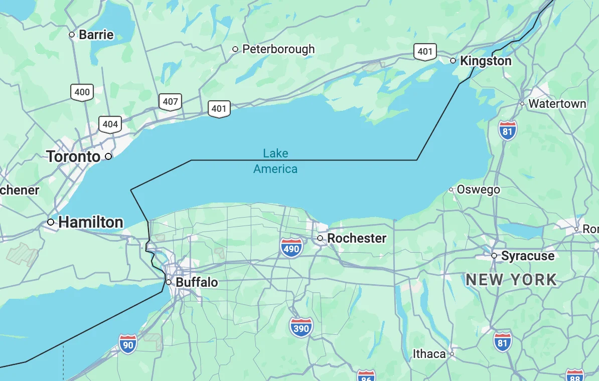
In a move that has rapidly reshaped digital cartography, Google Maps has officially updated its U.S. interface to reflect the renaming of Lake Ontario to "Lake America." This significant alteration, implemented late Saturday, follows an executive order issued by President Donald Trump earlier in the week, directing the rebranding of the easternmost Great Lake in official government databases. The decision marks a new chapter in the ongoing geopolitical tensions and trade disputes between the United States and Canada, highlighting the far-reaching impact of presidential directives on global information systems.
The genesis of this name change can be traced to a broader diplomatic conflict. President Trump’s executive order on Thursday is understood to be a strategic response to ongoing tariff disputes with Canada, a nation whose province of Ontario shares a significant border with the lake in question. This action echoes a similar directive issued by the President in January 2025, which saw the Gulf of Mexico officially rebranded as the "Gulf of America." That earlier renaming was also presented as part of a larger negotiation strategy with Mexico, another key trading partner.
The rapid adoption of the "Gulf of America" moniker by major digital mapping services, including Google Maps, Apple Maps, and Microsoft’s Bing Maps, set a precedent for subsequent governmental geographic name changes. These private companies generally align their digital representations with official U.S. government records, particularly those maintained by the Department of the Interior. The update to the federal government’s records, which occurred a few weeks after the initial "Gulf of America" order, directly influenced the mapping providers. Therefore, when the U.S. Department of the Interior updated its official databases to reflect "Lake America," it was largely anticipated that digital maps would soon follow suit.
Indeed, Google’s swift implementation on Saturday demonstrates a pattern of responsiveness to governmental data shifts. As of Sunday morning, the Geographic Names Information System (GNIS) database, a foundational resource for geographic names in the United States and a key informant for roadway signage and government literature, still listed "Lake Ontario" but included a clear notation that updates were in progress to reflect the official name change to "Lake America." This indicates a deliberate, albeit sometimes staggered, process of integrating the new designation across official channels.
The Role of Digital Mapping Providers in Geopolitical Narratives
While private entities like Google, Apple, and Microsoft are not legally compelled to adopt official government names for geographical features, they generally adhere to these designations to maintain consistency and accuracy within their platforms. The decision to follow the GNIS database, and by extension the President’s executive order, underscores the significant influence that government naming conventions hold in the digital realm. This reliance on official records allows for a unified understanding of geographical locations, which is crucial for navigation, planning, and information dissemination.
Google, in an unsigned statement released to the press, elaborated on the localized display of these evolving names. "People using Maps in the US will see ‘Lake America,’ those in Canada will continue to see ‘Lake Ontario,’ and those outside of the US and Canada will see both names," the statement explained. This nuanced approach acknowledges the varying geopolitical perspectives and historical naming conventions associated with the body of water. Google further emphasized that these updates are consistent with their "long-standing policy for bodies of water with names that vary from country to country, and are starting to roll out now." This suggests a sophisticated algorithmic approach that prioritizes user location and relevant geopolitical context.
Divergent Responses and the Open-Source Community
The implications of politically motivated name changes extend beyond major tech corporations. The open-source mapping community, notably OpenStreetMap, has become a focal point for public debate regarding the influence of governmental directives on digital cartography. OpenStreetMap’s technology underpins many services, including those provided by ride-sharing giants like Uber and Lyft. In contrast to the more centralized approach of major mapping services, OpenStreetMap’s decentralized nature allows for greater flexibility. The platform reportedly recognizes both U.S. and foreign names for geographical features, offering organizations the choice of which designation to display. This flexibility allows for a more inclusive representation of diverse perspectives and historical naming practices.
However, not all mapping providers have embraced the rapid adoption of the "Lake America" designation. MapQuest, a veteran in the online mapping space, has publicly declared its stance against the change. In a direct response to President Trump’s executive order on social media, MapQuest stated unequivocally, "We’re not changing it." This defiance highlights a potential divergence in how different mapping services navigate the intersection of political directives and their commitment to established geographical nomenclature. This resistance suggests that while government databases are influential, some companies may prioritize historical accuracy or editorial independence over immediate compliance with politically charged renaming efforts.
Historical Context and Precedents of Name Changes
The renaming of geographical features for political or diplomatic reasons is not a new phenomenon. Throughout history, nations have altered names of places to assert sovereignty, commemorate historical events, or reflect shifts in political power. For instance, after the fall of the Soviet Union, many cities and regions within former Soviet republics reverted to their pre-Soviet names or adopted new ones reflecting national identities. Similarly, during colonial periods, European powers often renamed indigenous lands to assert their control and erase existing cultural markers.
In the context of the United States, the renaming of bodies of water has historically been a less common occurrence, often driven by scientific or environmental considerations rather than geopolitical strategy. However, the recent executive orders by President Trump represent a distinct departure, leveraging the power of cartographic representation as a tool in international relations. The precedent set by the "Gulf of America" renaming, and now the "Lake America" designation, signals a potentially more assertive approach to using official naming conventions to influence perceptions and exert diplomatic pressure on trading partners.
Economic and Diplomatic Ramifications
The economic implications of such name changes, while seemingly abstract, can be far-reaching. For businesses operating within or near the affected regions, consistent and universally recognized place names are crucial for logistics, marketing, and consumer trust. A sudden shift in naming conventions can lead to confusion, requiring updates to signage, marketing materials, and internal databases. For instance, tourism boards and local businesses reliant on the identity associated with "Lake Ontario" may face challenges in adapting to a new, politically imposed name.
Diplomatically, the renaming of a significant geographical feature shared with a neighboring country can be perceived as a provocative act. While Google’s decision to display different names based on user location mitigates some of the direct cross-border confusion, the official U.S. designation of "Lake America" can still be viewed by Canada as an attempt to unilaterally redefine a shared resource. This could further complicate already sensitive trade negotiations and strain bilateral relations. The use of geographical names as a diplomatic weapon, however symbolic, adds another layer of complexity to international discourse.
The Technical Backbone: GNIS and its Influence
The Geographic Names Information System (GNIS), managed by the U.S. Geological Survey (USGS), plays a pivotal role in this process. GNIS is the official repository of domestic geographic names in the United States and its territories. It serves as the authoritative source for federal agencies, including the Department of the Interior, and informs the naming conventions used on maps, charts, and other government publications. The system is designed to ensure consistency and accuracy in geographic nomenclature, which is vital for national security, emergency response, and scientific research.
When a name change is officially adopted and entered into GNIS, it triggers a cascade effect across various sectors. Federal agencies are expected to update their internal systems and publications accordingly. Private companies, particularly those involved in data aggregation and information services like mapping providers, often monitor GNIS updates to ensure their own data remains current and aligned with official standards. This reliance on GNIS underscores its importance as a foundational element of the nation’s geographic information infrastructure. The process of updating GNIS itself involves a formal review and approval process, typically involving input from federal and state agencies, and sometimes public comment periods. However, in cases of executive orders, the process can be expedited.
Future Implications and Public Perception
The precedent set by the renaming of the Gulf of Mexico and now Lake Ontario raises questions about the future of geographical nomenclature in the United States. Will this become a recurring tactic in diplomatic negotiations, leading to a fluid and politically influenced landscape of place names? The reaction from the public and the open-source community suggests a growing awareness and concern about the potential for such changes to be driven by political expediency rather than historical or cultural significance.
The long-term impact on public perception and historical understanding remains to be seen. While digital maps can be updated, the historical memory and cultural identity associated with established names are deeply ingrained. The debate over "Lake America" and "Gulf of America" highlights the tension between official designations and the organic evolution of place names, which often reflect the history, culture, and identity of the people who inhabit a region. The stance taken by companies like MapQuest, prioritizing historical nomenclature over immediate compliance, may represent a growing sentiment within some segments of the public and the tech industry to resist politically motivated alterations of established geographical identities. The ongoing evolution of this situation will undoubtedly continue to be a subject of interest for cartographers, policymakers, and the public alike.
