

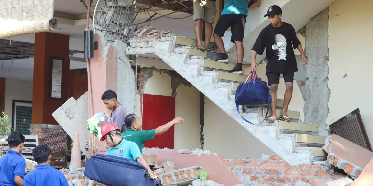
JAKARTA — A powerful magnitude 7.7 earthquake jolted the waters off Flores Island in Indonesia’s East Nusa Tenggara province on Saturday morning, August 15, 2026, claiming the lives of at least 38 people and leaving an unknown number of others feared buried or missing beneath the debris. The seismic event, which struck just before 6 a.m. local time, triggered widespread destruction, displaced over 2,000 residents, and severely damaged critical infrastructure across the region.
The Indonesian National Disaster Mitigation Agency (BNPB) confirmed the grim casualty figures and the extensive displacement during a press briefing in Jakarta on Saturday afternoon. BNPB head Suharyanto, who uses a single name, detailed the catastrophic impact, reporting that landslides had rendered many roads impassable, effectively isolating affected communities and hampering immediate rescue efforts. The damage extended to vital public infrastructure, with five airports sustaining significant damage, severely impacting transportation and the delivery of essential aid. Homes across multiple areas have been reduced to rubble, leaving survivors in desperate need of shelter and assistance.
While the earthquake’s epicenter was located at sea, approximately 700 kilometers east of the popular tourist destination of Bali, the tremors were so intense that they were felt hundreds of kilometers away, reaching as far north as the provinces of South Sulawesi and Southeast Sulawesi. The pervasive shaking caused panic and further destruction in these distant regions, compounding the national response to the disaster.
Immediate Aftermath and Rescue Operations
The port town of Maumere, the primary urban center in Sikka Regency on Flores Island, bore a significant brunt of the earthquake’s fury. Rescuers working in Maumere reported finding 20 deceased individuals, six injured, and two people still trapped under collapsed structures, according to Fathur Rahman, the head of the city’s rescue agency. Rahman emphasized the immense challenges faced by rescue teams, noting that some remote areas closest to the earthquake’s epicenter remained inaccessible, raising concerns that the death toll could rise as these regions are reached.
Social media platforms were inundated with harrowing videos depicting the chaos and destruction. Footage captured at Laurentius Say Port in Maumere showed scenes of panic as a boarding ladder detached and fell into the water, resulting in at least one person being plunged into the sea. These visual accounts offered a stark and immediate glimpse into the terror experienced by those caught in the initial moments of the quake and its subsequent aftermath.
Tsunami Threat and Seismic Activity
In the immediate hours following the initial tremor, Indonesia’s Meteorology, Climatology and Geophysics Agency (BMKG) issued a tsunami warning as a precautionary measure. While waves of less than a meter were recorded in several coastal areas, the warning was ultimately lifted after approximately two and a half hours, averting a more widespread coastal catastrophe. Nevertheless, the seismic activity did not cease with the main shock. The BMKG reported a relentless barrage of 235 aftershocks, with four registering magnitudes above 5.0. Forecasters warned that aftershocks were expected to continue for at least the next two weeks, posing an ongoing threat to already weakened structures and prolonging the anxiety of the affected population.
Nelly Florida Riama, an official from the BMKG, provided a scientific explanation for the earthquake during a briefing on Saturday morning. She stated that the seismic event was attributed to "back-arc thrust activity in the Flores Sea." This geological phenomenon occurs when tectonic plates interact beneath the ocean floor, generating powerful tremors.
Infrastructure Challenges and Communications Blackout
The earthquake’s impact on essential services has created a critical challenge for relief efforts. Widespread disruptions to electricity and communications have been reported across the affected areas. Suharyanto of the BNPB highlighted the immediate priority of restoring these vital lifelines, announcing the deployment of Starlink satellite internet services as a means to bridge communication gaps and facilitate coordination of rescue and relief operations. The inability to communicate effectively not only hampers emergency response but also cuts off affected families from the outside world, increasing their isolation and distress.
Geological Context and Volcanic Activity Concerns
The Geological Agency of the Ministry of Energy and Mineral Resources also dispatched teams to assess the disaster’s impact. Initial reports indicated that some areas experienced water rising from the ground following the earthquake, a phenomenon that can be indicative of soil liquefaction. Lana Saria, acting head of the Geological Agency, stated that while this observation suggested potential liquefaction, it had not yet been definitively confirmed, with the level of confidence currently rated as moderate to low.
Flores Island, situated in a volcanically active region, is home to 15 volcanoes. Notably, Mount Lewotobi Laki-laki, located in East Flores Regency, experienced a significant eruption in November 2024 and was reported to be active this week. However, Saria moved to quell any immediate fears of a link between the earthquake and heightened volcanic activity. She clarified that while the earthquake was detected by volcanic monitoring instruments, there was "no link between the earthquake and volcanic activity." Furthermore, Suharyanto confirmed that East Flores Regency, where Mount Lewotobi Laki-laki is situated, was not directly affected by Saturday morning’s earthquake, allowing for the potential redirection of emergency supplies stockpiled near the volcano to earthquake-stricken areas.
Historical Precedent and Indonesia’s Vulnerability
This catastrophic event on Flores Island carries a grim historical echo. The island was previously struck by a devastating magnitude 7.8 earthquake in 1992, which claimed the lives of approximately 2,000 people. This past disaster serves as a stark reminder of the region’s seismic vulnerability.
Indonesia’s geographical position along the Pacific Ring of Fire, a horseshoe-shaped zone of intense seismic and volcanic activity, renders it inherently susceptible to natural disasters. With 127 active volcanoes and a complex network of fault lines, the archipelago is perpetually on high alert for earthquakes, tsunamis, and volcanic eruptions. The recurring nature of such events underscores the persistent need for robust disaster preparedness, early warning systems, and resilient infrastructure to mitigate the devastating human and economic costs.
The scale of the devastation in East Nusa Tenggara on August 15, 2026, demands a comprehensive and sustained response. Beyond the immediate search and rescue operations, the focus will inevitably shift to providing long-term humanitarian assistance, rebuilding shattered communities, and reinforcing the nation’s capacity to withstand the relentless seismic forces that shape its landscape. The resilience of the Indonesian people will be tested once again as they confront the aftermath of this profound tragedy.
